

Surveying
 List of
Services
List of
Services
-
Property Line Surveys
-
Sub-divisions
-
Short Plats
-
Long Plats
-
Binding Site Plans
-
Boundry Line Adjustments
-
Legal Descriptions
-
Elevation Certificates
-
Topographical and Volume Surveys
-
Construction Layouts
-
Aerial Surveys
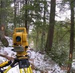
In over two and a half decades of operation, the professional staff at Mid-Mountain Surveyors, Inc. has gained extensive experience in cadastral (boundary) surveys, site topographic surveys, right of way surveys, photogrammetry (flight control) panel surveys, GPS control surveys, subdivisions, boundary line adjustment surveys, GIS surveys, flood plain study
surveys and underwater topographic surveys to name a few.
However, in recent years, it has been the construction projects that have seen the strongest growth and have propelled MMSI to invest in advanced technologies including robotics and real time kinematic GPS with Glonas and FCC licensed high powered repeaters. From preliminary site surveys, to
construction layout to as-built surveys of the completed projects, we apply the latest technology to bring high production and efficiency to any size project with a quality assurance protocol acquired over decades of experience.
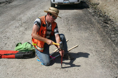
Our field crews even have onsite AutoCAD capabilities that together with communication with the design engineer can create real-time in-the-field fixes for the minor real-world problems that often arise during the course of a project. We understand how important it is to keep the crews and machines
working and thats why our field surveyors have the experience and resources to be flexible and even creative to help assure productivity from start to finish.
 |
 |
Professional Land
Surveyors
Certified Federal Surveyor, CfedS
Home About Surveying Portfolio Events Contact Us Estimate Payment
|
web design |
|